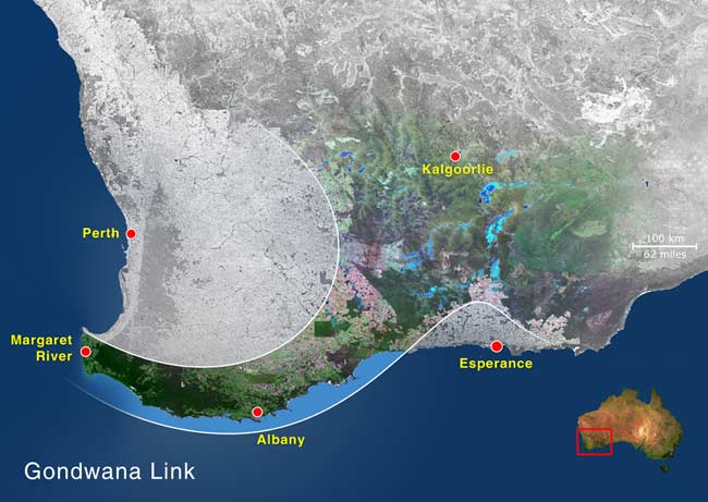
Bush Heritage Australia has been involved in the Gondwana Link connectivity project in the southwestern Western Australian biodiversity hotspot for 14 years. Over this time the management plan has cycled through a major adaptation based on implementation results. This case study outlines some experiences and learnings from an iteration of the Open Standards cycle. See the web page for Gondwana Link on this part of the Bush Heritage Australia website, and on Miradi Share.
Key lessons learned are:
- Choose Targets carefully
- Ensure that crucial knowledge gaps are filled as a priority so that Targets can be confirmed or changed
- Ensure that the major management strategies being employed are clearly linked to a Target and are monitored in a way that provides ecological outcomes
Gondwana Link
Gondwana Link is a collaborative conservation effort entering its fourteenth year of restoring ecological connectivity across south-western Australia; and protecting and restoring biodiverse bushland.

Gondwana Link stretches across 1,000 km in southwestern Australia
The Stirling-Fitzgerald portion of Gondwana Link was one of the earliest areas to be a focus of work when Gondwana Link began in 2002. The first conservation area was purchased by Eddy and Donna Wajon in 2002 – the 572 hectare Chingarrup Sanctuary. This was followed in 2003 by Bush Heritage purchasing the 898 hectare Chereninup Creek Reserve, and in 2004 by Greening Australia’s purchase of the Nowanup reserve (763 ha). Today 9,770 hectares (over 24,000 acres) is protected in privately-owned reserves, including some 3,900ha of cleared land that is being ecologically restored and some 580 ha under commercially-funded multi-species plantings.
The first Conservation Action Plan for Gondwana Link was completed in 2003 with support from The Nature Conservancy and input from Gondwana Link, Bush Heritage and Greening Australia staff and other interested individuals. The scope of the plan includes the Stirling-Fitzgerald portion of Gondwana Link which sits between the large Fitzgerald River and Stirling Range National Parks on the south coast of Western Australia. The main land use in the area is broad acre cropping and stock grazing, hence it is a highly fragmented landscape.
The goal in this area is to reconnect the national parks with a revegetated pathway. We chose six Conservation Targets with attributes and indicators for each of the targets, then identified and ranked threats and listed our knowledge gaps. A monitoring program was initiated to fill in some of the knowledge gaps and to monitor and evaluate the plan. So far so good, we were happy with our plan, and we continued to use it to guide our work over the next few years.
A key strategy in the plan is to restore cleared farmland to reinstate biodiverse native vegetation, reflecting the high biodiversity of the flora. A wallaby project has also been carried out to learn more about the Black-gloved and Tammar Wallabies – one of our Targets.
Lessons learnt
In 2011, when the time came to analyse the data, we discovered a few challenges in our plan. The biggest of which meant that although we were able to measure the health of our Targets, we hadn’t included the main plant community that our revegetation strategy was restoring – the Mallee Heath. This meant that the main management action being undertaken as part of our Plan couldn’t be reported directly against our goal of improving extent and condition!
A second discovery came as part of the wallaby project in that the Black-gloved Wallaby lived mostly in the Mallee Heath plant community, again not a Target. In addition, this species could be a good indicator of restoration success, as reported by Gilfillan, 2008:
“This species is a suitable target to measure increased habitat occupancy through habitat restoration and increased connectivity. Being relatively widespread and occurring in vegetation types that are quite common across the landscape, and given that it has already been observed using revegetation for both moving through and resting, it’s expansion onto currently unoccupied suitable habitat will almost certainly be enhanced by habitat restoration and increased connectivity.” (Wallaby monitoring sampling design (2008))
The third discovery was that Tammar wallabies used Mallet and Moort Woodland extensively for habitat and they could be a good indicator for the success of feral predator control, but not connectivity.
“Tammars should be maintained as an indicator for measuring the impact of fox control as they have been shown to respond to fox baiting (Kinnear et al. 2002), however, their occurrence as groups occupying small patches of habitat (which may be quite uncommon) suggest that they may not be a suitable target for measuring impacts of habitat restoration (the type of habitat being restored may not be suitable for Tammars) and increased connectivity.” (Wallaby monitoring sampling design (2008))
The fourth realization came when trying to analyse Yate Woodland and Creeks as separate Targets. Again, we found that they were inextricably linked.
The final challenge came with the Proteaceous Rich Heath Target – this vegetation community was very difficult to characterize and no two patches were the same, or even similar, hence it was not possible to monitor reference sites.
So, we had challenges with all but one of our Targets and we needed to be creative in addressing these challenges to enable us to better monitor and evaluate the project in subsequent years.
In 2014, the key stakeholders reviewed the plan and decided to add the Mallee Heath as a Target with the Black-gloved Wallaby as a nested target. This action subsumed the Proteaceous Rich Heath Target, and so now we are better placed to demonstrate that the restoration strategy is effective and is a key part of the plan to achieving some of our conservation goals. A single Target – Mallet and Moort Woodland and Tammar – was created, and Yate Woodland and Creeks were also combined into one Target. The result is four sensible and manageable Targets.
